
i-Boating:Marine Navigation Maps & Nautical Charts
by Gps Nautical Charts
Version 197.0
📅 Updated March 29, 2022
Chartplotter w/ Voice : Marine Navigation Charts & HD Lake Contour Maps

Features i-Boating:Marine Navigation Maps & Nautical Charts
This Marine Charts App offers offline nautical charts, inland river navigation charts, and lake contour maps for kayaking, yachting & sailing.First marine navigation app to have boat route assistance with Voice Prompts.
All features of a Marine Chart plotter in one app!It supports Nautical Charts course up orientation.
Incl Tide Charts & Currents prediction for nautical navigation.
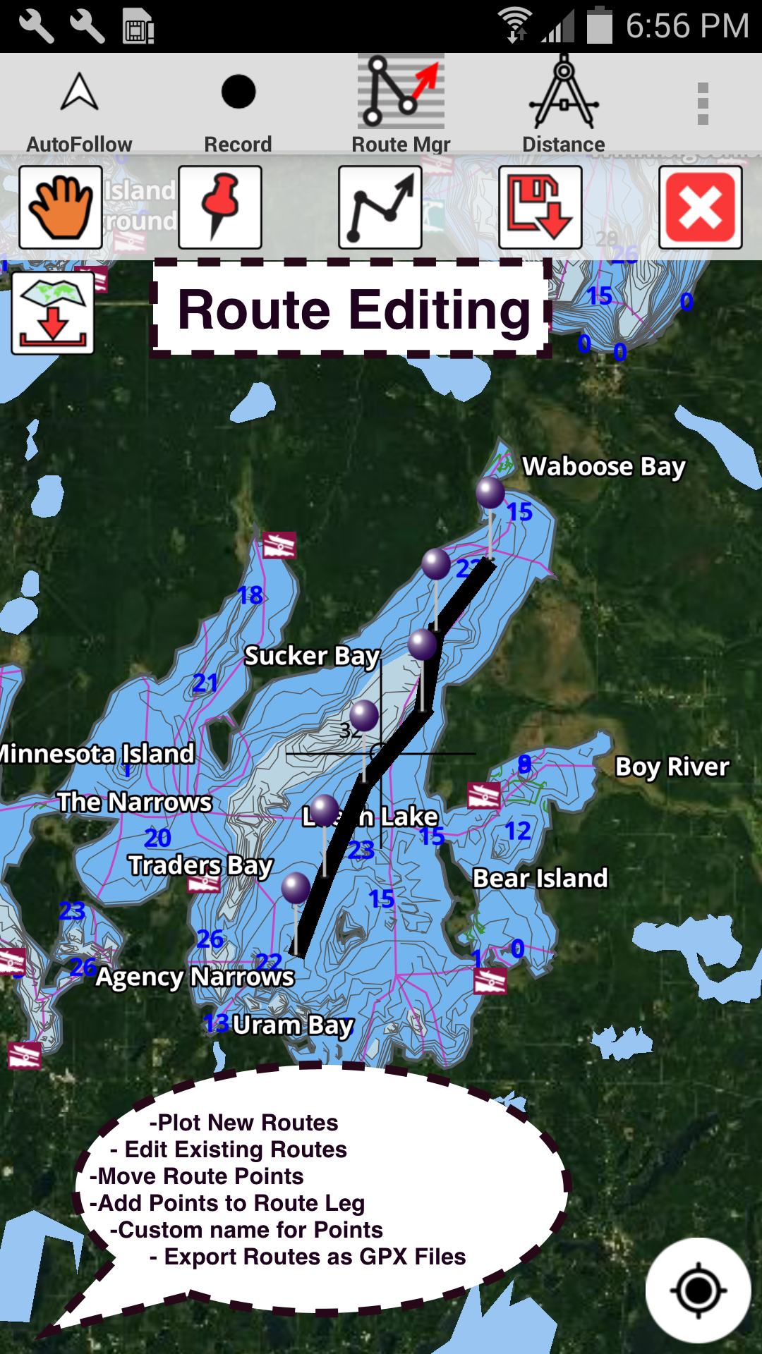
Create new boat routes / Waypoints, or import existing GPX/KML routes on device.
Has Marine AIS(NMEA) support.►FEATURES√ GPU accelerated offline vector NOAA charts/ENC charts (text stays upright on rotation)√ Lake depth map shading/safety lake depth contours: customize boat safety depth√ Maritime Aids to Boat Navigation : Beacons,Buoys,Boat Launch areas,Boat Ramps,Marina, Fishing Attractors etc√ Record marine tracks, Autofollow with real-time track overlay√ Voice Prompts for marine navigation√ HD 1ft/3ft depth lake contour maps for anglers for selected lake maps: for fishing/trolling(freshwater/saltwater).√ GPX/KML for boat route.√ Seamless marine chart quilting: Details from Coastal, Approaches,Harbour & Inland ENC (Electronic Marine Charts)√ Waypoints√ Tide & Currents.√ Marine AIS√ Anchor Alarm√ Magnify Text & Icons√ Wind Prediction Overlay√ Bearing True/Magnetic► MAPSAll details of marine chartplotters!Unlimited updates for 1 year.USA: Maps incl coverage of all NOAA marine charts,ENC,USACE inland river maps & freshwater lake bathymetry maps for more than 20K lakes.
Charts incl HD/1ft/3ft bathymetry for selected lakes.
Incl NOAA marine charts(rasters) where NOAA ENC coverage isnt available.Canada: CHS data Incl Great lakes(US & Canada sides),Alberta & Ontario lakes,Lake Simcoe&Trent Severn Canal,Quebec reservoirs.UK/Ireland: UKHO marine chartsGermany:BSH charts,Waterways & rivers.FranceEurope Inland Rivers:Donau/Danube/Dunaja,Rhine,Rhein,Garonne,Moselle,Drava,SavaAustraliaNetherland/HollandCroatiaFinlandNorwaySwedenRussiaBrazilSpainMalta,Cypress, Mediterranean SeaCaribbeanNew ZealandDenmark,Greenland,FaroeSeychelles,Mauritius,TanzaniaFalklandsMalaysia,South China SeaPersian/Arabian Gulf,Red SeaSouth AfricaArgentinaIcelandFijiEstonia,Latvia,Poland,LithuaniaTurkey,Greece,Italy►Instrumentation√ Marine AIS & (NMEA AIS and GPS over TCP/UDP)√ Wind direction & Speed,Marine Sonar depth,Water temperature►ROUTE MANAGEMENT /TRIP PLANNING√ Create/Edit/Reverse Boat Routes√ Waypoints mgt√ Import GPX,KML & KMZ files√ Share/Export Routes,Boating log, Tracks&Markers►FEATURES for BOAT NAVIGATION√ Auto Follow* Real Time Overlay & Predicted Path Vector* Course Up* Speed & Heading√ Route Assistance With Voice Prompts* approaching boating route marker prompt* Real time nautical distance & ETA* sailing/boating off route/wrong direction √ Record Tracks►TIDE & CURRENTS* High/Low Tides* Tidal Current Prediction* Active Current Stations► SHARING* Share tracks/Boat routes/markers/Waypoints* Export GPX files.► Satellite Imagery ► USA Marine Charts*Texas Lakes: Texoma,Eufaula,Toledo Bend*California Lakes:Tahoe, Shasta*Pennsylvania Lakes: Lake Raystown*Florida Lakes: Lake Okeechobee,Kissimmee*Minnesota Lakes: Lake Minnetonka,Waconia,Leech,Mille Lacs* Massachussets lakes Quabbin*Missouri Lakes: Truman*Ohio Lake maps of Lake hoover*Wisconsin Lakes: Lake Winnebago,Pepin* Utah Lake Powell,Bear*Maine Lake Sebago*Alaska Lakes: Lake Winnipesaukee*Tennessee Lake Barkley,Norris,Watts Bar*South Carolina Lake Keowee,Hartwell,Murray*Lake Michigan,Huron,Ontario,Superior,Erie► Canada Lakes Maps * Lac Saint Jean* Ontario Lake depth maps* Rideau Canal-Ottawa River* British Columbia Marine Charts* Pacific Coast-Vancouver- Haida Gwaii* Nova Scotia South-Bay of Fundy* Quebec-Anticosti Island* Newfoundland* St.
Lawrence river* Manitoba & Saskatchewan* Georgian Bay* Puget Sound► UK Nautical Charts* Scotland* Thames Estuary* Ireland► Australia Marine & Lake Maps* NSW * QueenslandMAJOR UPDATESlip to Slip Automatic Boat Routing-UK Tide & Currents-Magnetic Bearing-Wind Prediction Overlay-Magnify Text + Icons-Anchor alarm- Auto Pilot Support-Greenland-Custom depth shading-Satellite imagery-Water Level Offset-AIS & GPS NMEA TCP/UDP-Russian rivers(Volga)-Wind speed,direction,sonar depth,water tempNorway,Finland,Cyprus,DenmarkGerman(Donau,Elbe,Mosel,Rhein,Saar,Weser,Westoder)Europe Rivers AustriaBelgium Swiss-RhineElbe,Westoder,Ruhr,Mosel,Saar
Secure & Private
Your data is protected with industry-leading security protocols.
24/7 Support
Our dedicated support team is always ready to help you.
Personalization
Customize the app to match your preferences and workflow.
See the i-Boating:Marine Navigation Maps & Nautical Charts in Action


What Our Users Say
Don't just take our word for it. Here's what our users have to say about our Android app.
"I have this app on my iPhone. Works even better on my Android. Just seems faster."
Ryan Hassoun
"Its good for the small vechile."
Matt Frank
"Works fine with navlink2. Was able to use both gps and AIS over UDP broadcast. Surprised that it works as well as it does."
Mcintyre Masten
"So far the best app for Norman. Might even pay for the Paid version."
Byers Mustapha
"Worked good until it started shutting down when I would use auto follow."
Robert Zimmerman
"Been boating for a long time using many chart apps but none have the detail like i-Boating. Thanks to the team who put this together. No adds is important."
Ed Tavas
"Been playing with automatic boat routing. I like it so far. Does a good job routing around the shallows. Changing the boat draft does change the route. I am happy that it actually works."
Merrill Tero
"We are planning to do a portion of Americas Great Loop. This app will come in handy . It's the only app I have found that includes detailed depth maps and info for Erie Canal ."
Richmond Simona
"Very well"
mobius Lut
"Good backup plotter app. Now I don't need to be at the boat to plan."
Lester Pelham
Get the App Today
Available for Android 8.0 and above